Wednesday, May 26, 2010

Trail Report - 5/23/10 - Swansea Town Forest - MA

Hey!

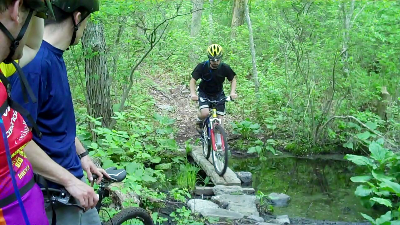
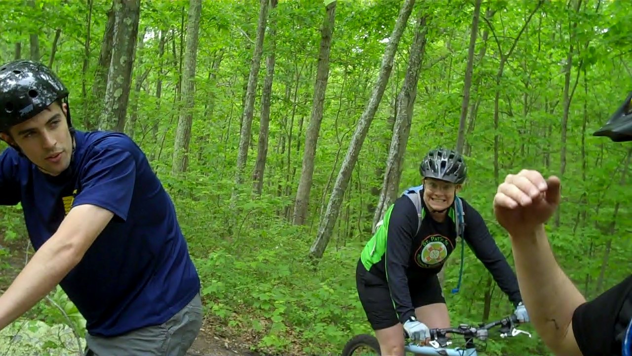
OMMB went riding with some kids.  Here's the VLOG highlights...


What's this?  A chip off the old block stuck to my shoulder?


CHOMP!


Honestly, I think there's a gnome in this picture!

- Trailhead: Swansea Library
- Riders: Greg, Patrick, Sara, Spencer, Teri, OMMB
- Distance: 5.25 miles
- Weather: great!
- Temp: 71
- Trail Conditions: dry with a touch of mud where expected ("you KNEW there was MUD down there!")
- Whoops, Yikes, and Oh Sheets: Patrick with a YIKES off the side of the Smoke Monster Seesaw!  Sara with an assumed WHOOPS (we only saw the damage).
Notes: A real good time!  Got a slow start due to the junk tubes OMMB has laying around in the shed but all went well...and no one got LOST!

Tidbits: A first...Greg on his new bike (a sweet ride).  A last... final episode of LOST is tonight!!!  (sigh)   (do you think Kate would consider riding with us sometime? ...oh alright Sawyer can go too!)

Happy Trails,
OMMB


oh wait, there's more! by special request...


Wednesday, May 19, 2010

Trail Report - 5/17/10 - Swansea Town Forest - MA

- Trailhead: Da Library
- Riders: T, OMMB
- Distance: 4 miles
- Weather: Clear
- Temp: 65
- Trail Conditions: real nice, dry
- Whoops, Yikes, and Oh Sheets: a clean ride on a dirty trail

Notes: Teri asked to take me for a ride...a bike ride.  It was a perfect day, so after work we did the typical loop in Swansea.  Trail conditions were real nice, Teri lead the way for most of the ride!

Tidbits: Hector's got a new kid to go with his 2 sons... it's a girl, born today!  Congrats to Hector Knievel and family!!!

Happy Trails,
OMMB

Monday, May 17, 2010

Trail Hike Report - 5/14/10 - Diamond Head (Le' ahi) Start Park - Honolulu, O'ahu, HI

- Trailhead: Park Main Entrance
- Hikers: Sadie, OMMB
- Distance: 1.6 miles
- Weather: partly cloudy then clear
- Temp: 85
- Trail Conditions: hardpack, some loose rock, rock ledge, cement steps
- Technical Level: easy enough for a caveman, not for an old lady
- Wildlife: some crazy girl running uphill with hand weights and balancing a bottle of water on her head...wild!
- Whoops, Yikes, and Oh Sheets: thankfully none for us, but an old lady must have fallen and she couldn't get up

Notes:  We hiked the historic trail to the top of Diamond Head Crater.  "The 0.8 mile hike from trailhead to the summit is steep and strenuous, gaining 560 feet as it ascends from the crater floor."  The view from the top is well worth the hike!  Near the summit there is a 225 foot tunnel. On the way down we got to witness a Fire and Rescue helicopter land on a peak and drop off two EMTs.  Apparently an older woman experienced some issues while climbing up.  After the EMTs checked her out, she was able to walk down with their help where an ambulance was waiting.  It was great that she attempted the vigorous hike...I guess.

Tidbits: Read the warning signs at the trailhead. If you don't understand English, find someone to translate!


Didn't know the Jetsons frequented O'ahu (do they know the Obama's?)...


Best way to curb hunger after a hike is a shrimp lunch plate on the North Shore...


Happy Trails,
OMMB

Click on...


Tuesday, May 4, 2010

Trail Report - 5/4/10 - Swansea Forest - Swansea, MA

- Trailhead: Swansea Library
- Riders: OMMB
- Distance: 4.5 miles
- Weather: cool, humid
- Temp: 64
- Trail Conditions: slightly wet due the rain this afternoon
- Wildlife:  Heard LOTS of Spring Peepers, nothing seen or squished. Listen here...http://en.wikipedia.org/wiki/File:Springpeepers.ogg
Notes: Had to wait for the rain storms to pass before heading out, so it was "lights on".   Something about riding in reduced daylight seems to make the trails more manageable.  It's a matter of just riding over the rough stuff without thinking about it... no time for your brain to tell you that danger approaches!

Tidbits: Investing in a good lighting system (head and bike mounted) is well worth being able to squeeze additional riding time out of a day.  If you don't have the money, find a nice wife to buy them as a gift for you!  ;)

Happy Trails,
OMMB


Monday, May 3, 2010

Trail Report - 5/2/10 - Freetown State Forest - Freetown, MA

- Trailhead: Main entrance to park, parking lot left
- Riders: Patrick, OMMB
- Distance: about 4 rocky miles
- Weather: perfect
- Temp: 77
- Trail Conditions: rocky, with some rocks, and some boulders, some bridges, some rocks, some roots but mostly rocks (get the idea?)
- Technical Level: Difficult, this trail is definitely not for beginners
- Whoops, Yikes, and Oh Sheets: Strange sight...I came around a corner and witnessed Pat balancing on his front wheel, staring down at the ground.  That only lasted for a few milliseconds before a professional slam down!  What started out as a very slow developing endo, ended in a very rude straight down dismount.  One "Oh Sheet" for Patrick!

Notes: This ride was kick-ass (as in ass kicking, kicked ass, ass breaking, etc).  We looped the single track off Bent Rim Trail (now that's an appropriate trail name) which presented more rocks and boulders than a dry river bed!  This trail was very challenging (but isn't that the fun part of the sport?), we were pretty kicked in a very short time (1 mile of rocks = 23 miles of tar).  Kind of embarrassing since we only covered a very small part of the park.  I spent a lot of time here when growing up in the neighboring town of Dartmouth, but covering the miles of trails was a bit easier on a dirt bike!

Tidbits: If you want a more leisurely ride, stick to the double-track.  Nice pine forests and sandy conditions similar to those found on Cape Cod.  Don't miss "The Ledge".

Happy Trails,
OMMB

Thursday, April 29, 2010

Trail Report - 4/29/10 - Swansea Town Forest - MA

- Trailhead: Swansea Library
- Riders: OMMB
- Distance: 4.5 miles
- Weather: clear
- Temp: 60, but felt cooler
- Trail Conditions: perfect... ding dong the mud is gone, the mud is gone, ding dong the wicked mud is gone...

Notes: Out for a late ride today, work just always intrudes on riding time!  BUT, gave me an opportunity to use my lights after the sun went down.  I had forgotten how fun (freaky) it was to ride a single track in the woods with just the beam of your light ahead of you!  It reminded me of the old days when my friend Mark would ride day or night (damn his legs were sexy then!).  To make things even more interesting, I followed some different side trails and loops over the rock outcroppings.  Now looking forward to another night ride soon!

Tidbits: My lights flashed on some glowing eyes.  Thoughts of coyotes (or worse yet, mountain lions) or wild dogs (wildcats), since I was riding near "Wildcat Rock", came to mind.  Also coming to mind was to strap a knife to my Camelback next time I ride at night. Thankfully the glowing eyes belonged to one of those stupid over sized poodles along for a hike with it's owners.  I hate poodles, small or large.

Happy Trails,
OMMB

Sunday, April 25, 2010

Trail Report - 4/24/10 - Big River West - East Greenwich, RI


- Trailhead: Burnt Sawmill Road
- Riders: T, OMMB
- Distance: 6.5 miles
- Weather: perfect, clear and cool
- Temp: 60's
- Trail Conditions: okay...still some huge mud pits!
- Whoops, Yikes, and Oh Sheets: no crashes, just one blood point for OMMB...gear bite (aka "MTB Badge of Honor")

Notes: T and I ventured out on a Saturday morning vs Sunday due to impending rain.  First time back to Big River West since the enduro race held here last season.  The trails recovered nicely...still some issues from the recent floods.  Going to take a while to dry out several of the mud holes!
Tidbits: One of our favorite loops even though tough going around the flood damage.  Loop is actually better in reverse direction (next time!).


Happy Trails,
OMMB


Friday, April 16, 2010

Trail Report - Wildwood - CA - Worst Ride Ever...

From Ronald Fong...

So, we decided to change things up a bit and go for a kinda new ride... Hector had sold us on this super awesome ride through wildwood with the best singletracks ever! Unfortunately he couldn't make it today, but Scott and I decided to forge ahead with the plan...... (should have done the regular ride instead).
Well, as soon as we started climbing up the hill, I noticed a sign... "Private Property" ... hmmm... that wasn't there before... so we just kept going. When we climbed to the top, the ground was full of broken glass, looks like the locals who owned the property was having a good time up there. But since we made it up the hill, we decided to keep going... that was a mistake... The "singletrack" turned into an animal trail, that was overgrown with CACTUS... by the way, did I mention the broken glass? Well it was also on the "singletrack". We finally found our way after getting lost at the top of the hill, to Santa Rosa trail. This was actually a really nice trail other than the fact we were climbing more than descending... we were going downhill... in an uphill way.... Oh, we were still looking for the crazy wicked "singletrack". Finally when we got to the top of the hill, we got a 1/4 mile drop into Wildwood, which I have to admit was fun except for the hikers who kept getting in the way, and the switchbacks that were so tight we couldn't ride them (I think the hikers made it that way on purpose... yeah). We rode the main fireroad in Wildwood up to the parking lot to pick up a map of the area, only to find that most of the trails are marked "hikers only", leaving us the fireroads... Well I told Scott that it a section down the hill didn't look too bad and it should be fun to ride, so we proceeded to drop 500FT or so into the valley. I was so excited when we finally dropped to the bottom of the valley to find the killer "singletrack", which unfortunately looked more like a fireroad. All wasn't lost as we managed to get lost and climb a Hell Hill like singletrack with switchbacks that was barely rideable, oh did I mention the overgrown cactus? So after climbing another fireroad we did manage to find a decent trail unfortunately it was uphill at that point, again overgrown with cactus. We decided it was time to quit and headed back to the parking lot only to find Scott had a flat tire. So after a quick change and a friendly guy with a floor pump giving us a hand, we were rewarded with a 3 mile ROAD ride back to the cars. Yes, a fantastic road ride on mountain bikes. But the BEST part is when I got home, both of my tires were flat... did I mention the overgrown cactus?

In summary, uphill, uphill, cactus, fireroad, uphill, cactus, road, 3 flat tires....

Wish you were there Hector!


Google Earth File http://www.garafa.com/GPSKit/tracks/2390c9bcc8697028e6d9bc88c39c51ca6a681d1e_42.kml
Google Maps Link
http://www.garafa.com/GPSKit/tracks/2390c9bcc8697028e6d9bc88c39c51ca6a681d1e_42.kml
GPX File http://www.garafa.com/GPSKit/tracks/2390c9bcc8697028e6d9bc88c39c51ca6a681d1e_42.gpx

Wednesday, April 14, 2010

Trail Report - 4/14/10 - Swansea, MA

- Trailhead: Swansea Library
- Riders: T, OMMB
- Distance: 3.2 miles

Notes: Yep, went for a quick little ride after work... it was fun.

Tidbits: This was just a quick little report.

Happy Trails,
OMMB

Monday, April 12, 2010

Trail Report - 4/11/10 - Big River East - RI

- Trailhead: Hopkins Hill Rd Parking Lot
- Riders: Chris, Patrick, Spencer, OMMB
- Distance: 4.5 miles tracked, at least a mile longer
- Weather: clear
- Temp: 59
- Trail Conditions: some areas of single track were trashed by random mid-woods waterfalls
- Technical Level: very
- Wildlife: some flying turkey or pheasant or something
- Whoops, Yikes, and Oh Sheets: a season opener endo by Spencer (log hopped a bouncy log, log bounced him over the handlebars), a whoops and a Holy Sheet by Patrick...end result of a rocky decent.

Notes: We decended from the right side of the parking lot and turned right into what used to be solid single track.  Most of the trail was washed out by what appeared to be random waterfalls,  not close to any rivers or ponds.  Pat had a little sideways whoops, no biggie.  His brakes were not working very well. We continued on, then stopped so Pat could adjust his brakes.  After crossing several small streams we climbed a nasty rock outcropping.  No one made it up without stopping.   After the climb, the trail dried up okay.  We stopped so Pat could figure out what was wrong with his middle front gear.  It had a bent tooth, not a bent crank.  We hit the double track for a half mile or so and jumped back into the woods where we found more stream and mud crossings.  After getting to higher ground, we stopped so Pat could pump up his rear tire (starting to see a trend?).  After several rock gardens and rest stops to fill Pat's tire, Spencer lost the battle with a bouncing log.  NICE endo!  It was time to leave the single track behind and take a rocky decent back to the double track that circles the lake.  Did I mention "rocky decent"?  Did I mention Pat had issues with brakes?  Did I mention his rear tire was loosing air?  The end result of these points looked like a scene from CSI!!!  A Holy Sheet crash due to loosing the line on a downhill with too much speed.  Luckily no serious injury, only a nasty scrape and bruised leg. We cruised back to the lot after crossing a pretty deep stream (bike wash!).   Pat climbed the last hill riding the rim, flat rear tire!

When CSI showed up, they had no clue as to "what the hell happened?"


Tidbits:
This trail was pretty difficult (heard of the "perfect storm"? this ride featured the "perfect trail"!!)
Click On: Google Earth File


Happy Trails,
OMMB

- 1 mud point for Spencer
- 1 blood point for Patrick

Some pix by SOL...one of many mid-woods streams...


Left Coast - 4/8/09 - Los Robles - CA


Awesome last ride with Juan this Thursday! Can you figure out what's wrong with the last picture? (Hint: the bike was serviced by Hector and Scott's tire changing company)

RoFo


Google Earth File http://www.garafa.com/GPSKit/tracks/2390c9bcc8697028e6d9bc88c39c51ca6a681d1e_32.kml

Google Maps Link http://maps.google.com/maps?q=http://www.garafa.com/GPSKit/tracks/2390c9bcc8697028e6d9bc88c39c51ca6a681d1e_32.kml

GPX File http://www.garafa.com/GPSKit/tracks/2390c9bcc8697028e6d9bc88c39c51ca6a681d1e_32.gpx


Sunday, April 11, 2010

Trail Report - 4/7/10 - Swansea Forest - Swansea, MA

- Trailhead: Swansea Library
- Riders: T, OMMB
- Distance: 3.8 mi
- Weather: clear
- Temp: 60
- Trail Conditions: getting better, but not totally dry
- Wildlife: T scared the crap out of a poor defenseless red squirrel
- Whoops, Yikes, and Oh Sheets: a whoops by T, her buckin bike bucked her off the back

Notes: went out for a nice little last minute ride after work...(actually had a hard time keepin up with that spunky girl today!!)
Tidbits: the track...

Happy Trails,
OMMB

Wednesday, April 7, 2010

Trail Report - Solo Vander-Ride - 4/4/10 - Los Robles "lost" trail, CA

Highly bummed I couldn't make Gridley. So bummed that I rode solo on Sunday. I'll call it the Los Robles "lost" trail...

I'd say the ride was 10-12 miles with perhaps 1500 feet of climbing and comprised of single-track, fire road, sketch fire road and sketch single-track. I started at the Los Padres trailhead. It's a beautiful oak shaded cruise up to the Hillsborough access fire road. It's a cruise except for the granny gear inducing & lung exploding final 3 switchbacks. The fire road is an easy 1/2 mile climb to the los robles trail intersection. At this point I always go right...so I went left. After another mile of ups and downs on the fire road I spied a right hand single-track descent and took it. After a 1/4 mile I spied a wicked looking single-track climb. I proceeded to climb most of this and then reached another intersection. I went right (left was hike-a-bike) and rode single-track to another fire road that overlooks hidden valley. So at this point I'm not sure where to go...but then I see some hikers behind and below me. I backtracked and found a nice completely overgrown sing track descent to a "new" housing community in Lake Sherwood. The descent was easy but so overgrown as to become dicey when the trail was lost. Since I'm now 20 miles by paved road from my car, I went back the way I'd come. No big deal, but, the wicked single-track climb was a great descent...and I had to climb the hike-a-bike just to see if could descend it At the intersection of the hillsborough fire road I went my usual way on los robles and descended via the ultra steep fire road (just to see if I could do it) and then out los robles to the oak creek loop to paved road.

Good times and no broken derailleur's...and I made all those descents though my rear brake is now in need of a bleed...

Tim

(aka "Vander-Magellan")

Trail Report - 4/3/10 - Gridley Trail - Ojai, CA

- Trailhead: Gridley Rd
- Riders: Scott, Ron, Hector
- Distance: 12.5 miles
- Time: 2 hrs to the top, 25 min down (approx)
- Weather: clear
- Temp: mid 60's at the bottom, mid 50s at the top
- Trail Conditions: dry and compact (except for some creek crossings)

Juan was a no show to his own farewell ride and Tim couldn't come. Ron felt good enough to show and ride. Like usual, we started the climb from the parking area. Ron was coughing up green stuff so he was tailing. At the start he didn't look too good so we kept a slow but steady pace, but as we progressed he started to feel stronger so we raised the pace. At mile 3, Ron's bike derailleur hanger decided to quit and broke in half. He hiked back down while Scott and I continued to the top. At the top we ate a snack then rode back down stopping a few times to extend and enjoy the awesome down-hill. Ron was already down by the cars. We had the usual chips and Dos-X's and then drove to Ojai for a nice lunch.

Note: For our east coast friends not familiar with this trail, Gridley is probably the best single-track trail in the county and surrounding areas. This trail provides some spectacular views of the Ojai Valley, Channel Islands and the rugged mountains of the Los Padres National Forest. What makes Gridley an awesome trail is the variety of terrain, from exposed to shaded, from firm to loose, crushed rock, rocky, and sometimes rutted technical sections (6.2 miles of pure up-hill and 6.2 miles of pure down-hill). Also is the rollercoaster thrill factor, Gridley traverses (many switchbacks) along the side the mountains starting from an elevation of approx 700ft to 3700ft so at one side you have the mountain and the other side the cliff, which can get to several hundred feet deep, yes a freefall down-hill if you make a mistake. On a serious note, I learned about this trail some years back while watching the news about a rider that went over and got killed. Anyway, you are welcome to come and ride with us...

Hector
One too many rock gardens on Ron's bike....

Post ride beer and derailleur.....

Gridley Track...

Sunday, April 4, 2010

Trail Report - 4/2/10 - Swansea Town Forest, MA

- Trailhead: Swansea Library
- Riders: OMMB
- Distance: 4.25 miles
- Weather: clear, VERY nice!
- Temp: 68
- Trail Conditions: Still wet and muddy but not as bad as expected

Notes: Went out for an expected mud fest... really not much worse than before the "Great Flood of RI". Looking forward to see how Big River fared the storm real soon...

Tidbits:
1) Found the camera strap I lost 2 weeks ago!
2) Rode an extra wide tire on the rear to handle the muddy conditions...worked well but I need to adjust my front derailleur where the tire occasionally rubbed.

Happy Trails,
OMMB

Thursday, April 1, 2010

Trail Report - 4/1/10 - Mount Washington Auto Road - Pinkham Notch, New Hampshire

- Trailhead: Route 16, 2 miles north of Wildcat Ski Area
- Riders: Teri, OMMB
- Distance: 7.6 miles
- Weather: Clear & cool, wind speed 16 mph (luckily very low)
- Temp: 61 at base, 46 at summit
- Trail Conditions: tar...all the way up
- Technical Level: extreme hill climbing skills needed
- Climb: grade averages 12 percent, 22 percent in final yards before the 6288-foot summit (highest peak in Northeast)
- Wildlife: 2 mountain goats, a rare sight!
- Whoops, Yikes, and Oh Sheets: no issues climbing, luckily we were not allowed to descend

Notes: Last night we found out that the mountain road is open to bike riders each year on 1 April.  So, knowing that the sun was finally going to shine today, we drove up to Mt Washington this morning.  We arrived at the mountain around 10:30, checked in at the gate, and got ready to climb.  The ride took a brutal 3.5 hours but the views along the route and at the summit were unbelievable!!  Although a decent would have been wild, we were happy to ride back down on the cog railway (http://www.thecog.com/).

Tidbits: 
1) I recommend attempting this ride whenever possible, great way to prepare for the West Coast rides...be sure to bring PLENTY of water and high protein food source
2) The highest wind speed ever recorded was on Mount Washington (231 mph)
3) Be sure to stop at Flatbread's in North Conway on the way home...awesome brick oven pizza!


Happy Trails,
OMMB


APRIL FOOLS !!!!!

Wednesday, March 31, 2010

Trail Report - Circle X - CA

From: Ronald Fong
Sent: Wednesday, March 31, 2010 1:13

Well went to the doctor this afternoon. Looks like bacteria in the lungs. Taking antibiotics now. Can't believe I got sick off this ride. Bike computer says 21 miles but gps is only 19...

Google Earth File http://www.garafa.com/GPSKit/tracks/2390c9bcc8697028e6d9bc88c39c51ca6a681d1e_28.kml

Google Maps Link http://maps.google.com/maps?q=http://www.garafa.com/GPSKit/tracks/2390c9bcc8697028e6d9bc88c39c51ca6a681d1e_28.kml

GPX File http://www.garafa.com/GPSKit/tracks/2390c9bcc8697028e6d9bc88c39c51ca6a681d1e_28.gpx

Sunday, March 28, 2010

Trail Report - 3/28/10 - Big River East - West Greenwich, RI

- Trailhead: Hopkins Hill Rd Parking Lot
- Riders: Teri, Pat, Chris, OMMB and Spencer...Spenc? Bueller? Bueller? ...anyone?
- Distance: 5 plus a little miles
- Total climb: 2.5 miles (not as high as Spenc was last night)
- Weather: Clear and COLD (colder than ALL the beer Spenc dumped down is throat last night)
- Temp: 35 (something like those 35 ounce beers Spenc drank last night)
- Trail Conditions: attempted to stay on the higher ground...to no avail.  Some deep water and mud (muddy like Spencer's brain this morning)!
- Whoops, Yikes, and Oh Sheets: wasn't notified of any mishaps...close call when Patrick went barreling through the 15 inch deep stream attempting to pass OMMB...think not (there was as much water in that stream as Spenc had beer last night)!

Notes: With more impending rain (it was raining beers for Spencer last night), we were glad to kick off the Sunday Morning Group Ride this morning.  Some unexplainable sliced tire issue causing a bulge on OMMB's bike delayed our start, but we got a great ride in.  Although one rider short (hmmm), we worked through some real technical single track that offered rocks, mud, water, and hills.  We found some trails new to us on the far east side of the area...but of course Spencer didn't get to ride this, he was still na-nights. 

Tidbits:
1) Chris has got some fast legs, he wants us to sign up for a race (but of course we would have to make sure it's scheduled around Spencer's sleepy time)
2) Teri did an awesome job keeping up with the boys today...great effort!
3) New Trail Quote by Chris & OMMB... "well that's a nice bulge you got"  "I've been waiting for someone to tell me that my whole life!"

Happy Trails,
OMMB

Saturday, March 27, 2010

Trail Report - 3/25/10 - Sycamore Canyon - Point Mugu State Park, CA

- Trailhead: Sycamore Canyon Fire Road, Pacific Coast Highway
- Riders: Hector, Scott, Tim, OMMB
- Distance: 13.5 miles
- Climbs: 2.5 miles
- Weather: clear & dry, cooler as the sun went down
- Trail Conditions: hardpack, ruts, loose rock
- Whoops, Yikes, and Oh Sheets: given the danger of the fast downhill, surprisingly no wipeouts

Notes:  Got a late start, so lights were ready.  We climbed Backbone (what I call "back break") and decended on Guadalasca (1, 13, 11, 10, and 7 on the map below)...well worth the climb (which is brutal for someone from the east!). The downhill run is the best thrill around! I felt pretty good climbing, possibly due to knowing what to expect. 


http://venturacountytrails.org/TrailMaps/Sycamore/AreaTrails.htm#Map

Tidbits:  The mountains are soooo green this time of year!  Awesome views all around from the summit.  The after ride refreshments were the best...home made green salsa & chips washed down with Newcastle Brown Ale.  These guys are the most enjoyable and generous riders your going to find anywhere! I really appreciate their friendship.

Happy Trails,
OMMB

Trail Report - 3/23/10 - Sycamore Canyon - Point Mugu State Park, CA


- Trailhead: Sycamore Canyon Fire Road, Pacific Coast Highway
- Riders: Hector, Scott, Juan, OMMB
- Distance: 14.5 miles
- Weather: clear & dry
- Temp: 70
- Trail Conditions:  hardpack with some ruts from recent rain
- Wildlife: ground squirrels, lizards, a snake (Hector inadverdantly gave the snake a lesson about crossing bike paths...ouch)
- Whoops, Yikes, and Oh Sheets: one slight whoops by Scott.  It's tough in the large washed out ruts, one got him! ...all good

Notes: My first west coast ride with new parts, felt surprisingly good...especially after the post ride brews!  We rode out on the Fire Road, then Two Foxes, and looped Hidden Pond...awesome variety of terrain!

Tidbits:  knee high socks to keep the bugs off, legs warm, and reduce scratches from cactus/brush...good idea!


Happy Trails,
OMMB

Monday, March 22, 2010

Trail Report - 3/21/10 - Swansea Town Forest - MA

- Trailhead: Swansea Library
- Riders: Patrick, Mark, OMMB
- Distance: 4 miles
- Weather: cool, but nice
- Temp: 45-ish
- Trail Conditions: getting better
- Whoops, Yikes, and Oh Sheets: 1 Whoops for OMMB (looked back to check status and plopped over sideways), 1 Yikes for Mark over a water & mud crossing (buried the front end with an endo, resulting in a flat rear tire, huh?), and 1 Yikes for Patrick (which could have easily been an Oh Sheet) during the first attempt at the quite large seesaw (see the video)

Notes: got Patrick out for his season opener; as usual...a natural

Tidbits: one mud point for Mark, one "beyond the call of duty" point for Patrick (as daunting as the seesaw was, he did it first!)

Happy Trails,
OMMB

Trail Report - 3/19/10 - Swansea Town Forest - MA

- Trailhead: Swansea Library
- Riders: T, Anna, Mark, OMMB
- Distance: 4 miles
- Weather: great
- Temp: was supposed to be about 70, although it felt much cooler
- Trail Conditions: still quite muddy and wet, but getting better
- Whoops, Yikes, and Oh Sheets: good clean ride, even for those on their season opener!

Tidbits: I think "hop, hop" means "hurry up, keep going because I don't feel like unclipping my shoes to stop...even if others may need a break!!" ;)

Happy Trails,
OMMB

Thursday, March 18, 2010

Trail Report - 3/18/10 - Weetamoo Woods - Tiverton, RI

- Trailhead: End of Lafayette Rd (North side of WW) - Riders: OMMB
- Distance: 5 miles
- Weather: perfect
- Temp: 68
- Trail Conditions: I'm surprised there aren't any Water Buffalo native to New England
- Technical Level: intermediate to expert (some trails are very rocky)
- Wildlife: just a friendly retriever, likes to chase bikes

Notes: Awesome day for an "almost" Spring ride!

Happy Trails,
OMMB

Trail Report - 3/17/10 - Swansea Town Forest - Swansea, MA

- Trailhead: parking lot behind the Swansea Public Library
- Riders: OMMB
- Distance: 4 miles
- Weather: NICE!!
- Temp: 58
- Trail Conditions: muddy and wet where they was never mud and water before!
- Technical Level: intermediate
- Wildlife: a hawk

Notes: With all the rain and flooding the area has had, the mud holes were so deep they would startle a water buffalo! The mucky conditions throughout the otherwise normal single-track made for tough going. Even the bridges over small streams were washed out. I attempted to stay on higher ground so investigated some trails over the many rock outcroppings...turned out to be fun stuff.


Tidbits: Greg the Italian boy is really mostly Irish... who knew?

Happy Trails,
OMMB

Wednesday, March 10, 2010

Trail Report - 3/10/10 - Swansea Town Forest - Swansea, MA

- Trailhead:  parking lot behind the Swansea Public Library
- Riders: OMMB
- Distance: 5 miles
- Weather: clear and chilly (the day warmed up later...I think this pseudo-Spring is ending)
- Temp: 35
- Trail Conditions: good
- Technical Level: intermediate
- Climbs: 15%
- Wildlife: hawk or pheasant or something flying fast
- Whoops, Yikes, and Oh Sheets: 1 whoops off a log bridge and into the cold mud (good news... 1) I got up, 2) didn't land in the stream)

Notes: Pushed out an early morning ride in an another attempt to get the strength built up this week...yes now I'm sore,  ...but feeling much better on the bike each day.  Still not ready to ride with Bikeworks just yet (nor with those Left Coast animals).

Tidbits:  Trailhead behind the library is better than (meaning there are no rivers to cross) behind Colt Jr High.

Happy Trails,
OMMB

PS-Sunday Morning Group Rides will be coming very soon..........

Monday, March 8, 2010

Trail Report - 3/8/10 - Swansea Town Forest - Swansea, MA

- Trailhead: Case Jr. High  - Riders: T, Mark, OMMB
- Distance: 4.5 miles
- Weather: clear, windy
- Temp: 60
- Trail Conditions: some mud, not too bad
- Technical Level: beginner/intermediate
- Climbs: 15%
- Whoops, Yikes, and Oh Sheets: n/a

Notes: We couldn't resist taking advantage of this psuedo-Spring (60 degrees in March? It's still Winter!!)

Tidbits:  The Bikeworks crew has built a pretty large seesaw here, bigger than the one at Big River (remember Hector Kneivel?).  Did NOT try it this time...MAYBE next time (can you say "baby"???)

Happy Trails,
OMMB

Sunday, March 7, 2010

Trail Report - 3/6/10 - Swansea Town Forest - Swansea, MA

- Trailhead:  Case Jr High - Riders: T, OMMB
- Distance: 4 miles
- Weather: clear
- Temp: 50+
- Trail Conditions: typical New England Spring conditions...water, mud, mud, and mud
- Technical Level: beginner/intermediate
- Climbs: 10%
- Wildlife: 2 Trail hounds (Jack Russell Terriers)...no worries, they liked us
- Whoops, Yikes, and Oh Sheets:  clean ride (aside from the muddied bikes and legs!)

Notes: the forecast for 3 consecutive days of 50 degree temps drove us to celebrate an early Spring (even if short lived)... so yard work, mtb ride, and a G&T sunset by the fire had us looking forward to many more days like this!!

Tidbits: I need thorn proof tire/tubes!!!

Happy Trails,
OMMB